Planning your survey
- + Map for your site
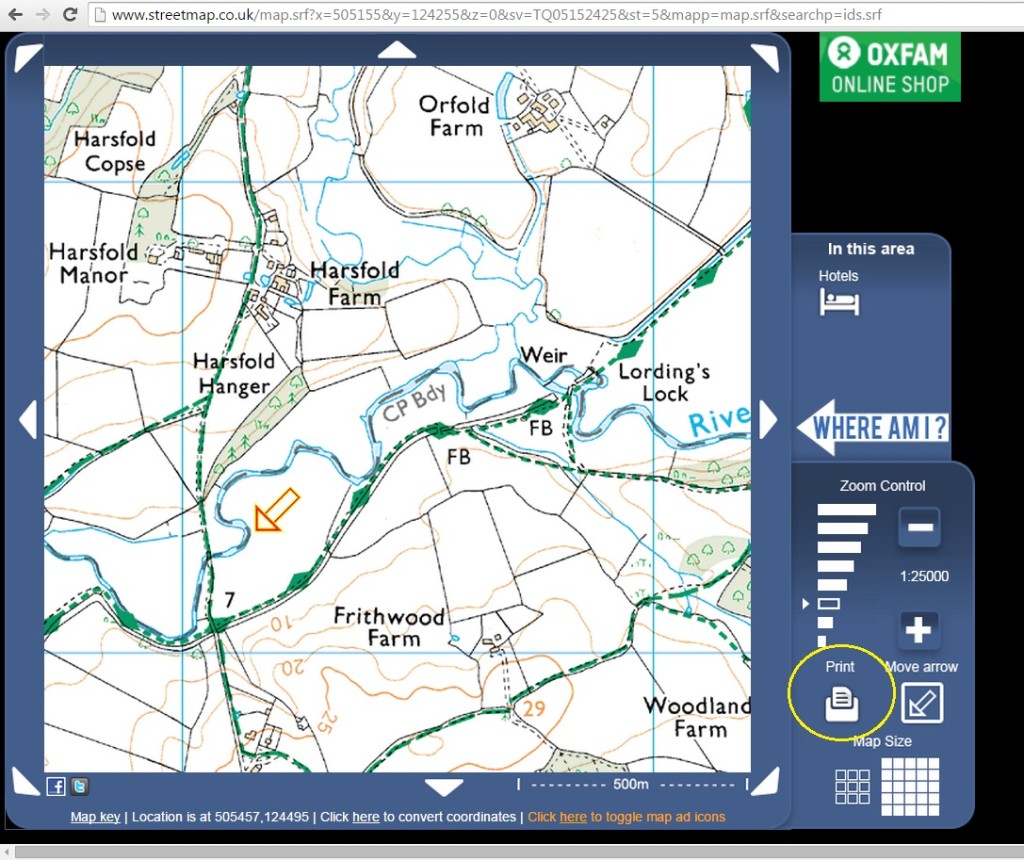
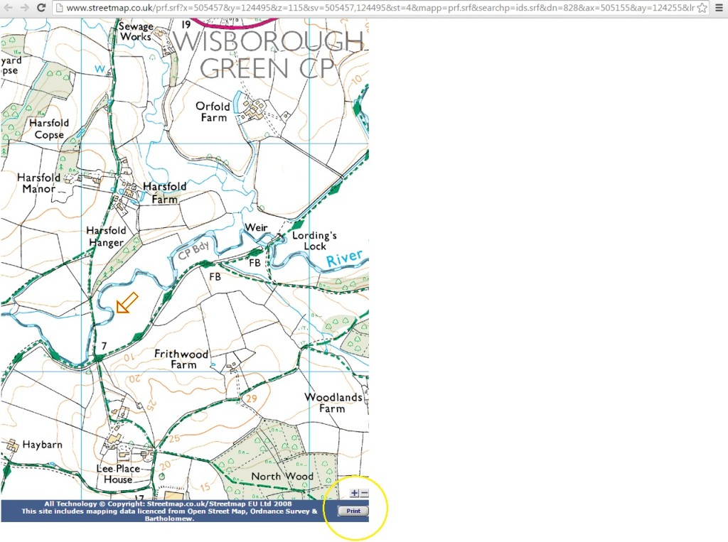
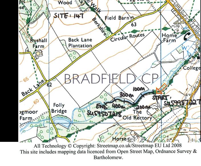
Once you have chosen a site to survey, you will then be able to log in and click on your site’s profile which includes a Google map showing where your site is located. We also recommend using a website called Streetmap to find your site’s central location by using the site’s grid reference. From here, you’ll be able to see nearby public footpaths and access roads, as well as geographical features of the square such as rivers, roads, field boundaries and houses.
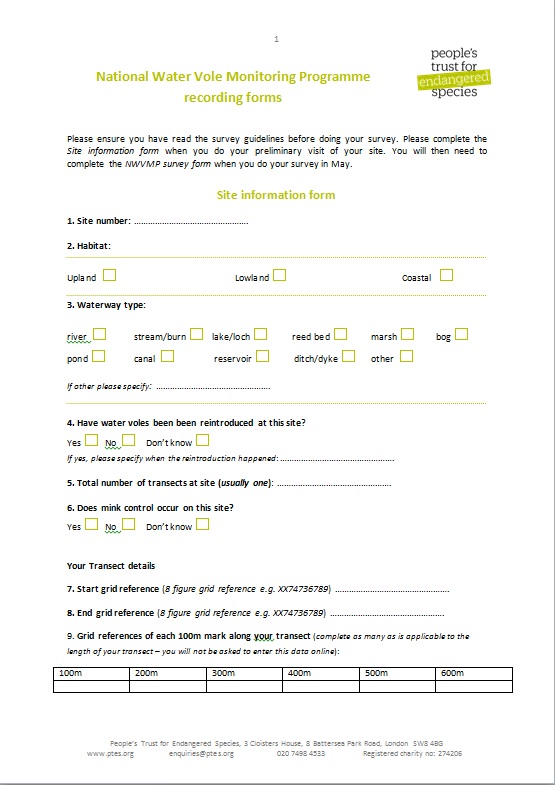
- + Site information form
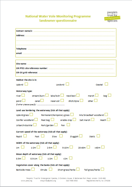
When you visit your site prior to doing your survey between 15th April and 15th June you will need to take and complete the site registration form. You will then need to enter this data using the online version of this form.
The form asks you to record information on:
- The habitat your site is in (upland, lowland or coastal)
- The water way type you will be surveying along (e.g. river/stream/ditch)
- Whether you know if there has been a water vole reintroduction at the site.
- Total number of transects at the site (for most sites this will be one)
- Whether mink control happens at the site (either whether there is a mink raft present on the waterway or you can ask the landowner about this)
We are asking you to record this information so that we can get an understanding of what factors might be affecting water vole presence/absence at a site level.
- + Planning your transect
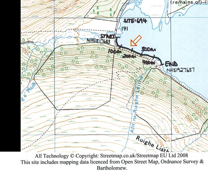
You will need to survey one bank of a 500m stretch of waterway (transect) at your site, recording any field signs within each 100m section, as this will allow for the best comparison with the historical data we have and also allow standardisation between all the sites being monitored.
In some squares there will only be one waterway and so that will be where you walk your transect. In others there may be a couple of options so when you visit your site to fill in the site information form you can choose which waterway to walk your transect along – it may be that one has much better access e.g. a public footpath/right of way running along beside it or only one is long enough to walk a 500m transect.
The easiest way to measure out your 500m transect is to pace it out along the bank. Most people take about 110/120 paces per 100m. You can either pace out your transect when you visit your site to record the site information and then mark on your map the 500m transect you will survey and 100m lengths within this.
Alternatively you can wait and when you go to your site to do the survey you can pace out your transect at that stage, marking each 100m length and then walk back along the transect doing your survey.
Whichever way you decide to do this, you will need to walk in the same direction each time you do your survey.
Once you have decided on where your transect will start and end, you can record the grid references for both the start point and the end location on your site information form.
+ Working out the GPS location for the start and end of your transect
This can either be calculated using a handheld GPS device or most smart phones will have an app you can download to calculate this (such as the OS Locate app or Gridpoint GB app). If you don’t have a GPS handheld device or a GPS app on your phone, then you can mark the location of the start/end of your transect on your map and then once you have access to the internet you can go to www.gridreferencefinder.com Once there, zoom in on your site and then right click over the location of the start/end point – you will then be told the grid reference/longitude and latitude figures for that location and can record this information on the record form.
If for any reason it is not possible to conduct a 500m transect in your grid square then it is possible to conduct a shorter transect (any denomination of 100m) though please do notify PTES by emailing watervoles@ptes.org along with the reason for it not being possible to survey 500m at your site.
- + Landowner’s permission
You will be able to check the map of your site to see if any footpaths or rights of way run along the waterway or if the site is accessible to the public. However, even if you are able to do your survey by walking along the right of way/footpath, it is still advisable, polite and in some cases a legal requirement to contact the landowner or landowning organisation before carrying out your survey on their land. This is to check they are happy for you to continue and to explain what you will be doing and when you will be doing it.
If your waterway runs through private or restricted land then you MUST get permission from the landowner to enter and conduct your survey.
Often the easiest way to find the landowner is to knock on the door of the nearest house and enquire. We recommend you take someone with you if you are doing this.
We have included a landowner permission letter at the end of the survey guidelines for you to print out and take with you which identifies you to landowners and explains what you are doing.
When you ask the landowner for permission, please also give them a copy of the Land Owner Questionnaire Pack and ask them to complete it and return it PTES using the freepost address at the bottom of the second page.
Download a printable version of these guidelines and the Land Owner Questionnaire Pack
Next: Searching for field signs
Training menu:
• An introduction to the NWVMP
• Planning your survey
• Searching for field signs
• Carrying out your survey
• After your survey
• More training links
Feedback – we would really value your feedback on these training pages and also on the monitoring programme. Please email any comments to watervoles@ptes.org.